India is a land of diversity, where we just do not have many languages and many cultures but we also have diverse physical features like the desert, snowy mountains, long coast, evergreen forests, and fertile plains. We have some highest peak like Kanchenjunga and Nanda Devi in India which stands in top mountain peaks in the world.
Not only the Himalayas but also, there are other beautiful hills and peaks in the state like the famous peaks of western and the eastern ghats.
In this article, we have given the details of the top 10 highest peaks to visit in India. Other than this, look at some of the best places that you can visit in Himachal Pradesh, or some of the best places to visit in the monsoon in India.
| Name of the Highest Peaks | Height |
| Kanchenjunga Peak | 8,586 meters |
| Nanda Devi Peak | 7,816 meters |
| Kamet Peak | 7,756 meters |
| Saltoro Kangri peak | 7,743 meters |
| Saser Kangri Peak | 7,672 meters |
| Mamostong Kangri Peak | 7,516 meters |
| Rimo Peak | 7,385 meters |
| Hardeol Peak | 7,151 meters |
| Chaukhamba Peak | 7,138 meters |
| Trisul Peak | 7,120 meters |
- Explore The Prehistoric Cave Paintings From Hundred Thousand Years Ago In Faridabad
- Top 10 Weekend Getaways From Delhi
- Top 10 Places To Visit On A Budget In India
- Top 10 Destinations To Visit In Winter In India
- Top 10 High-Altitude Treks In India
- The 12 Jyotirling Temples Of Lord Shiva In India
1. Kanchenjunga Peak

Height: 8,586 m
Location: Sikkim
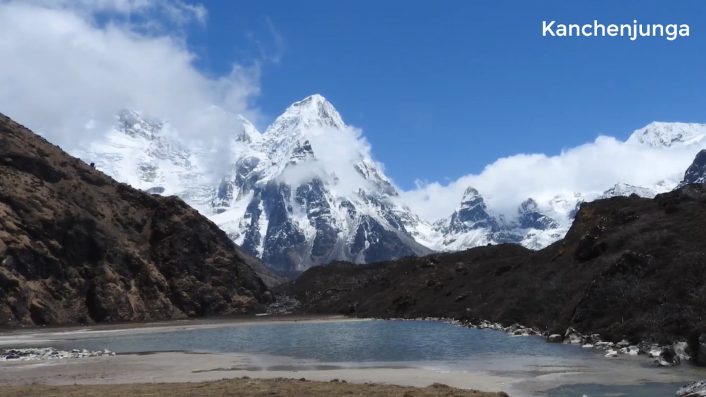
Kangchenjunga, also known as Kanchenjunga, is the highest peak in India and the third-highest in the world. It is located at the border of India and Nepal, surrounded by snow-capped mountains at a height of 8,586 meters (28,169 ft, which is the highest point in India) in the great Himalayas range of Sikkim.
Kangchenjunga means “The Five Treasures of High Snow” in the Tibetan language which refers to its five peaks, out of which four are over 8,450 meters. It has a lot of religious significance in Buddhism. The climber stopped short of the summit to fulfill the promise given to the Chogyal (Former ruler of the Kingdom of Sikkim) that the top of the mountain would remain intact.
How to Reach?
By Air: The nearest airport would be Bagdogra Aiport, which is around 153 km away.
By Train: First, you need catch a train to reach Darjeeling Railway Station and then cover the rest 85 km by a taxi.
Through Road: One can reach here by driving 31 hours straight from Delhi, which is about 1,600 km.
2. Nanda Devi Peak

Height: 7,816 m
Location: Uttarakhand
Nanda Devi is the second highest mountain summit at an elevation of 7,816 meters in the Garhwal Himalayas region in the state of Uttarakhand, India. Nanda Devi, which means “Bliss-Giving Goddess”, is considered the patron goddess of the Garhwal and Kumaon Himalayas.
How To Reach?
By Air: The nearest airport to Nanda Devi is Jolly Grant Airport, which is about 295 km away from site.
By Train: The nearest railway station to Nanda Devi is Rishikesh railway station which is 276 km away.
Through Road: it is just 334 km away from Delhi by road.
3. Kamet Peak

Height: 7,756 m
Location: Uttarakhand
Kamet is one of the highest peak in India and the highest summit in the Zaskar Mountain Range of the Garhwal region in the Chamoli district of Uttarakhand. Kamet is surrounded by three principal neighboring; Mukut Parbat, Abi Gamin, and Mana Peak.
Kamet is very remote and not as much accessible as some other Himalayan peaks, because of its position near to Tibetan plateau.
How To Reach?
By Air: The nearest airport is Jolly Grant situated in Dehradun. From there you have to take a bus or taxi to reach the final destination.
By Train: The nearest railway station is Haridwar.
Through Road: It’s just 344 km away from Delhi by road.
4. Saltoro Kangri Peak

Credit: peakvisor
Height: 7,742 m
Location: Jammu & Kashmir
Saltoro Kangri is the highest peak of the Saltoro Mountains, that is why it is also known as the Saltoro Range, which is a subrange of the Karakoram range in Karakoram, India.
The Saltoro Kangri ranks 31st in the list of a highest independent mountain summit in the world with an elevation of 7,742 meters (25,400 ft) in Kashmir, India.
How To Reach?
Through Road: It’s approx. 744 km away from Delhi.
5. Saser Kangri Peak

Credit: seeyouinthemountains
Height: 7,672 m
Location: Jammu & Kashmir
Saser Kangri is the easternmost subrange of the Karakoram range, which is also the highest peak in the Saser Muztagh with an elevation of 7,672 meters (25,171 ft) and ranking 35 in the world.
How To Reach?
By Air: First you need to reach Leh, then you can go further to Saser Kangri. To reach Leh you have to take a flight to Kushok Bakula Rimpochee Airport, from there Saser Kangri is 81 km away.
Through Road: The distance between Delhi to Saser Kangri is 688 km.
- Explore The Prehistoric Cave Paintings From Hundred Thousand Years Ago In Faridabad
- Top 10 Weekend Getaways From Delhi
- Top 10 Places To Visit On A Budget In India
- Top 10 Destinations To Visit In Winter In India
- Top 10 High-Altitude Treks In India
- The 12 Jyotirling Temples Of Lord Shiva In India
6. Mamostong Kangri Peak

Height: 7,516 m
Location: Jammu & Kashmir
Mamostong is the highest peak in the remote region in Rimo Muztagh, which’s a subrange of the Karakoram range in Ladakh, Union Territory of India. It is the 48th highest independent summit in the world elevated at a height of 7,516 meters (24,659 ft).
How To Reach?
By Air: The nearest airport to Mamostong Kangri is Kushok Bakura Rimpochee Airport (Leh).
Through Road: The distance between Delhi to Mamostong Kangri is 717 km.
7. Rimo Peak

Height: 7,358 m
Location: Jammu & Kashmir
The main summit of Rimo massif is Rimo I with an elevation of 7,358 meters (24,229 ft). It’s 71st highest mountain peak in the world, which is located about 20 km from the northeast of the snout of the Siachen Glacier
How To Reach?
Through Road: The distance between Delhi to Rimo is 740 km.
8. Hardeol Peak

Credit: tourmyindia
Height: 7,151 m
Location: Uttarakhand
One of the major peaks of Kumaon Himalaya is known as Hardeol or the ” Temple Of God”. It is situated in the northern end of the Milam Valley, in Pithoragarh district of Uttarakhand.
How To Reach?
By Air: Pantnagar Airport is the closest to the Hardeol, which is 188 km away.
By Train: The closest railway station is the Ramnagar railway station.
Through Road: The distance between Delhi to Hardeol is only 349 km.
9. Chaukhamba Peak

Height: 7,138 m
Location: Uttarakhand
Chaukhamba I is the main summit in the main group and has the highest peak as well. It’s a part of the Gangotri group of ranges which includes a total of four peaks.
How To Reach?
By Air: The nearest airport to Chaukhamba Peak is Jolly Grant situated in Dehradun, India.
By Train: The nearest railway station is Haridwar.
Through Road: Its 368 km away from Delhi by road.
10. Trisul Peak

Height: 7,120 m
Location: Uttarakhand
Trisul is a group of three Himalayan mountain peaks of western Kumaun, with an elevation of 7,120 meters, which is one of the highest mountain summit in India. The three peaks make a trident – which is Trisul in Hindi, one of Lord Shiva’s weapons.
How To Reach?
By Air: The nearest airport to the Trisul peak is Pantnagar Airport.
By Train: Ramnagar is the nearest railway station to the Trisul peak.
Through Road: The distance between Delhi and Trisul summit is 314 km.
All above mentioned were the highest peaks in India. Check out more great post


2 Responses
Nice Blog Post